


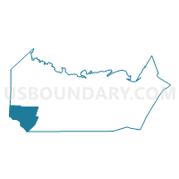
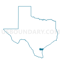
Voting District 0036, Nueces County, Texas
About
Outline

Summary
| Unique Area Identifier | 676157 |
| Name | Voting District 0036 |
| County | Nueces County |
| State | Texas |
| Area (square miles) | 64.54 |
| Land Area (square miles) | 64.16 |
| Water Area (square miles) | 0.38 |
| % of Land Area | 99.40 |
| % of Water Area | 0.60 |
| Latitude of the Internal Point | 27.63420860 |
| Longtitude of the Internal Point | -97.84972150 |
Maps

Graphs
Select a template below for downloading or customizing gragh for Voting District 0036, Nueces County, Texas


Neighbors
Neighoring Voting District (by Name) Neighboring Voting District on the Map
- Voting District 0009, Jim Wells County, TX
- Voting District 0011, Nueces County, TX
- Voting District 0012, Nueces County, TX
- Voting District 0014, Nueces County, TX
- Voting District 0023, Kleberg County, TX
- Voting District 0025, Kleberg County, TX
- Voting District 0027, Nueces County, TX
- Voting District 0102, Nueces County, TX
Top 10 Neighboring County Subdivision (by Population) Neighboring County Subdivision on the Map
- Kingsville CCD, Kleberg County, TX (30,027)
- Alice CCD, Jim Wells County, TX (29,098)
- Bishop CCD, Nueces County, TX (6,694)
Top 10 Neighboring Place (by Population) Neighboring Place on the Map
Top 10 Neighboring Unified School District (by Population) Neighboring Unified School District on the Map
- Kingsville Independent School District, TX (26,603)
- Alice Independent School District, TX (25,647)
- Bishop Consolidated Independent School District, TX (5,365)
- Riviera Independent School District, TX (1,582)
- Agua Dulce Independent School District, TX (1,537)
- Driscoll Independent School District, TX (1,406)
Top 10 Neighboring State Legislative District Lower Chamber (by Population) Neighboring State Legislative District Lower Chamber on the Map
- State House District 35, TX (151,882)
- State House District 43, TX (148,370)
- State House District 34, TX (143,582)
Top 10 Neighboring State Legislative District Upper Chamber (by Population) Neighboring State Legislative District Upper Chamber on the Map
Top 10 Neighboring 111th Congressional District (by Population) Neighboring 111th Congressional District on the Map
Top 10 Neighboring Census Tract (by Population) Neighboring Census Tract on the Map
- Census Tract 9502, Jim Wells County, TX (7,932)
- Census Tract 201, Kleberg County, TX (5,602)
- Census Tract 61, Nueces County, TX (3,392)
- Census Tract 59, Nueces County, TX (3,302)
Top 10 Neighboring 5-Digit ZIP Code Tabulation Area (by Population) Neighboring 5-Digit ZIP Code Tabulation Area on the Map
- 78363, TX (30,463)
- 78332, TX (28,710)
- 78380, TX (23,141)
- 78343, TX (4,525)
- 78330, TX (878)
- 78351, TX (621)